The Roxton Walk.
The Roxton circular walk passes through grassy meadows, along the banks of the River Great Ouse, and through Roxton, one of the most attractive village High Streets in Bedfordshire. The complete route is about 4 kms (2 1/2 miles) in length, but a short cut provides a route of just over a mile. There is much water based wild life to be seen on the walk as well as wild flowers in season.
It should be noted that the walk crosses meadowland which may contain sheep or cows and several stiles need to be climbed. Along the river the path can be muddy when the weather is wet, and in winter the path may occasionally be flooded. In early Summer the rapid growth of vegetation along the river may make the wearing of shorts inadvisable.
Location
Roxton is situated some 7 miles East of Bedford, near the junction of the A421 and the A1, on Ordinance Survey maps of 1:50000 scale Landranger 153 and at 1:25000 the Explorer 208. Roxton Village grid reference TL153546.
Parking
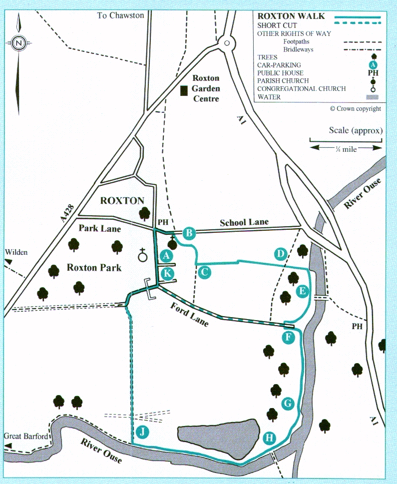
Convenient parking is available in the High Street near the Parish Hall ( A on the map) at grid ref. 153546. Please park with consideration.
Refreshments
Refreshments are available at the Royal Oak Pub in Roxton close to the parking, and at the Anchor, located across the river at point (E).
Waymarking
All the footpaths are well marked. Look out for the circular route (CR) yellow waymarks which indicate the direction of the walk. Other rights of way are waymarked with yellow or blue discs. Yellow arrows are used on public footpaths, blue on public bridleways.
Acknowledgements
This walk has been developed by Roxton Parish Council with support from Bedfordshire County Council under the Parish Paths Partnership scheme. The text has been written and the sketches provided by Mr and Mrs Bryan Mitchell.
Roxton Walk leaflets of the above are available from The Bedford Information Centre, 10 St. Pauls Square, Bedford, UK, phone (01234-215226) or e-mail jackpike@bigfoot.com.
.
The walk starts at the entrance to the Parish Church in School Lane (B on the map). Pass diagonally through the churchyard keeping the church on your right; make for a large Weeping Willow tree and pass through the fence via a Y gate. Continue along a clearly defined path which passes between two arable fields; note the small pond on the right which usually contains ducks and sometimes a moorhen or two.
(C) Turn left at the waymarking post and follow the path which passes alongside a newly planted grove containing a variety of trees. (D) The walk crosses another footpath, continue downhill through a small copse and then over a small footbridge. Enter a large field (via a stile), cross the field keeping the hedge on your left and exit via another stile. Maintain an easterly direction until the next waymark post when the walk swings right and continues parallel to the river which can be seen through the trees.
(E) Pass the footbridge which spans the River Ouse on your left and continue to the bottom of Ford Lane from where walkers can return to the village if they wish (F). Cross the lane and the ditch (by a footbridge) and then enter a narrow meadow (via a stile). Follow the waymark sign and turn left. Keeping the fence on your left proceed to the river bank and turn right; follow the bank upstream, cross over a wide ditch (via a footbridge) and continue to the field boundary (G). Exit via a stile and follow the path across a bridge over the old Roxton Lock. Pass over another stile and observe the new modern lock on your left, which was built in 1972 (H). Do not cross the river.
Pass the National River Authority building and access the river bank via a Y gate. Keep to the bank with the river on your left and continue upstream noting the large trout lake on your right. This is a good spot to see heron and the occasional king-fisher, and the lake abounds with coot, great crested grebe, mallard and tufted ducks, Canada and greylag geese.
(J) Turn right at the signpost and follow a wide grassy path which leaves the river and leads back to the village. On arriving at Ford Lane, follow the lane to the right leading to a small triangular green (K). Turn left into the High Street and back to the Parish Hall.
Roxton High Street
Take time to appreciate some of the lovely buildings in the High Street - most of the old buildings date from the 17th century and are timber framed. The white thatched cottages and tarred farm buildings are backed by the fine trees of Roxton Park.
The interesting Congregational Church, set back on the left, was orinially a barn. It was converted into a place of worship by Charles Metcalfe, the Lord of the Manor. Later two wings were added and the entire block thatched.
The red bricks of Roxton House may be glimsed in Roxton Park. The house dates from the 17th century, but was re-fronted in the 18th century and enlarged in the 19th century.
Parish Church
The Parish Church of St. Mary dates from the 14th century, with a 15th century West tower. The churchyard has fine trees, walls and hedges, and some interesting gravestones.
Last modified Nov 2002